


Beemer & Logan Precinct, Cuming County, Nebraska
About
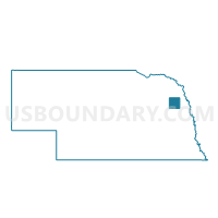
Outline

Summary
| Unique Area Identifier | 612622 |
| Name | Beemer & Logan Precinct |
| County | Cuming County |
| State | Nebraska |
| Area (square miles) | 71.69 |
| Land Area (square miles) | 71.13 |
| Water Area (square miles) | 0.56 |
| % of Land Area | 99.22 |
| % of Water Area | 0.78 |
| Latitude of the Internal Point | 41.95074770 |
| Longtitude of the Internal Point | -96.78019060 |
Maps

Graphs
Select a template below for downloading or customizing gragh for Beemer & Logan Precinct, Cuming County, Nebraska


Neighbors
Neighoring Voting District (by Name) Neighboring Voting District on the Map
- Bancroft, Cleveland & Neligh Precinct, Cuming County, NE
- St. Charles Sherman Garfield & Cuming Precinct, Cuming County, NE
- SW 4, Cuming County, NE
- Wisner, Blaine & Grant Precinct, Cuming County, NE
Top 10 Neighboring County Subdivision (by Population) Neighboring County Subdivision on the Map
- Wisner city, Cuming County, NE (1,170)
- Beemer township, Cuming County, NE (862)
- Bancroft township, Cuming County, NE (668)
- Sherman township, Cuming County, NE (544)
- Elkhorn township, Cuming County, NE (253)
- Garfield township, Cuming County, NE (231)
- Logan township, Cuming County, NE (201)
- Cleveland township, Cuming County, NE (181)
- Bismark township, Cuming County, NE (178)
- Neligh township, Cuming County, NE (177)
Top 10 Neighboring Place (by Population) Neighboring Place on the Map
Top 10 Neighboring Unified School District (by Population) Neighboring Unified School District on the Map
- West Point Public Schools, NE (5,951)
- Wisner-Pilger Public Schools, NE (2,559)
- Pender Public Schools, NE (1,848)
- Bancroft-Rosalie Community Schools, NE (1,159)